Loading...
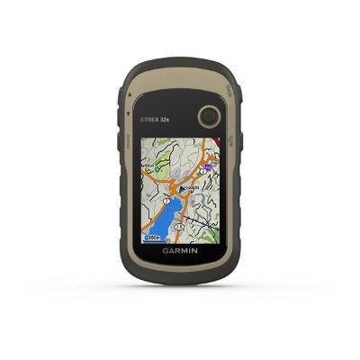
GPS eTrex 32x, Garmin
Garmin | SKU:
900-52889
$299.99
Unit price
/
Unavailable
GPS eTrex 32x, Garmin Pre-order Now and Receive Real-Time Shipping Updates

GPS eTrex 32x, Garmin
$299.99
Unit price
/
Unavailable
The eTrex 22x and 32x handheld devices come preloaded with road-routable TopoActive maps that feature streets and trails so you can take the journey off the grid. Now you can know your surroundings — such as waterways, natural features, buildings, and more. The eTrex series uses both GPS and GLONASS satellite systems so the receiver has the ability to track in more challenging environments than GPS alone. eTrex 32x adds a 3-axis compass and barometric altimeter, making it easy for you to keep your bearings.
General |
|
| DIMENSION | 2.1" x 4.0" x 1.3" (5.4 x 10.3 x 3.3 cm) |
|---|---|
| DISPLAY SIZE | 1.4" x 1.7" (3.5 x 4.4 cm); 2.2" diag (5.6 cm) |
| DISPLAY RESOLUTION | 240 x 320 pixels |
| DISPLAY TYPE | 2.2" transflective, 65K color TFT |
| WEIGHT |
5 oz (141.7 g) with batteries |
| WATERPROOF | IPX7 |
| BATTERY TYPE | 2 AA batteries (not included); NiMH or Lithium recommended |
| BATTERY LIFE | 25 hours |
| INTERFACE | mini USB |
| MEMORY/HISTORY | 8 GB |
Maps & Memory |
|
| PRELOADED MAPS |
Yes (TopoActive; routable) |
|---|---|
| ABILITY TO ADD MAPS | Yes |
| BASEMAP | Yes |
| AUTOMATIC ROUTING (TURN BY TURN ROUTING ON ROADS) FOR OUTDOOR ACTIVITIES | Yes |
| MAP SEGMENTS | 3000 |
| INCLUDES DETAILED HYDROGRAPHIC FEATURES (COASTLINES, LAKE/RIVER SHORELINES, WETLANDS AND PERENNIAL AND SEASONAL STREAMS) | Yes |
| INCLUDES SEARCHABLE POINTS OF INTERESTS (PARKS, CAMPGROUNDS, SCENIC LOOKOUTS AND PICNIC SITES) | Yes |
| DISPLAYS NATIONAL, STATE AND LOCAL PARKS, FORESTS, AND WILDERNESS AREAS | Yes |
| EXTERNAL MEMORY STORAGE | Yes (32 GB max microSD™ card) |
| WAYPOINTS/FAVORITES/LOCATIONS | 2000 |
| TRACKS | 200 |
| NAVIGATION TRACK LOG | 10000 points, 200 saved tracks |
| NAVIGATION ROUTES | 200 routes, 250 points per route; 50 points auto routing |
Sensors |
|
| HIGH-SENSITIVITY RECEIVER | Yes |
|---|---|
| GPS | Yes |
| GLONASS | Yes |
| BAROMETRIC ALTIMETER | Yes |
| COMPASS | Yes (tilt-compensated 3-axis) |
| GPS COMPASS (WHILE MOVING) | Yes |
Daily Smart Features |
|
| VIRB® REMOTE | Yes |
|---|---|
Outdoor Recreation |
|
| POINT-TO-POINT NAVIGATION | Yes |
|---|---|
| AREA CALCULATION | Yes |
| HUNT/FISH CALENDAR | Yes |
| SUN AND MOON INFORMATION | Yes |
| GEOCACHING-FRIENDLY | Yes (Paperless) |
| CUSTOM MAPS COMPATIBLE | Yes (100 custom map tiles) |
| PICTURE VIEWER | Yes |
Connections |
|
| CONNECTIONS WIRELESS CONNECTIVITY |
Yes (ANT+®) |
|---|---|
MPN 010-02257-00
